 Mt. Kaikoma or Kai-koma-ga-take is located in the northern part of the Southern Alps. Its altitude is 2967m. And I think it is the most beautiful mountain in the Southern Alps.
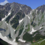
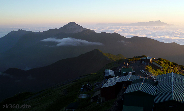
 Photo 1: Mt. Kaikoma in the morning as seen from Kita-dake. The building on the lower right is kata-no-koya hut, and the mountains on the upper right are Yatsu-ga-take. (2017/8/2)
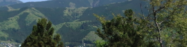
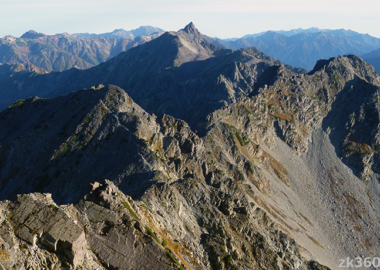
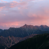
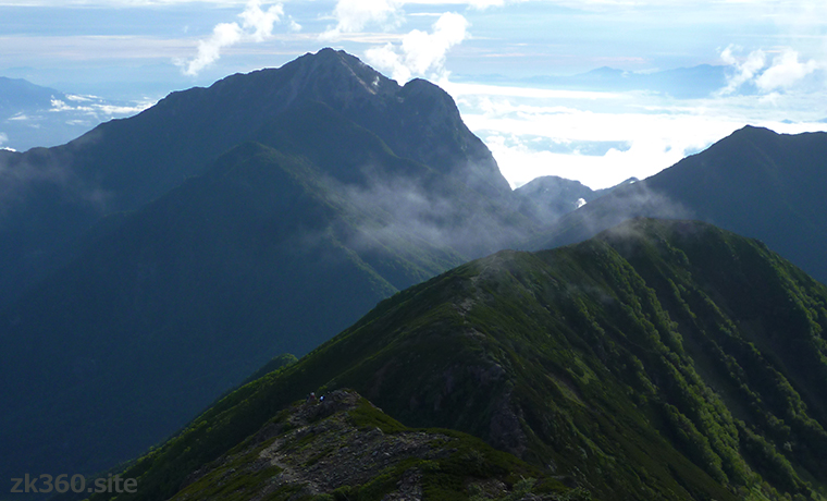
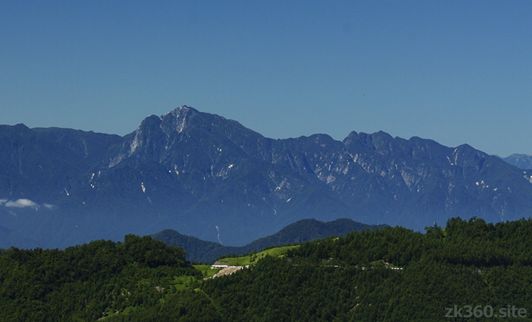
 Photo 2: Mt. Kaikoma in the morning seen from the ridgeline between Senjo-ga-take and Ko-senjo-ga-take. The large mass on the right is called Marishiten. (2016/8/3)
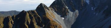
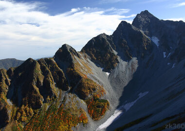
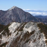
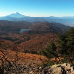
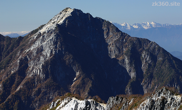
 Photo 3: Mt. Kaikoma seen from near Jizo-dake in Houou-zan. The shape of the mountain stands out. The white mountains in the back are the Northern Alps. (2003/10/24)
 Photo 4: Mt. Kaikoma seen from Mt. Kentoku in Yamanashi Prefecture. The mass on the left is Marishiten, and the jagged edges on the right are Mt. Nokogiri. (Photo: 2002/9/2)
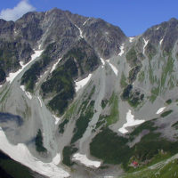
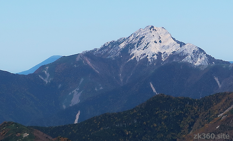
 Photo 5: Mt. Kaikoma seen from Mt. Shiomi. The granite sand makes it look white as if it were covered with snow. And it is difficult to walk near the summit. (Photo: 2019/10/9)
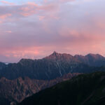
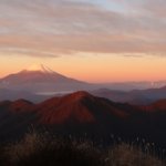
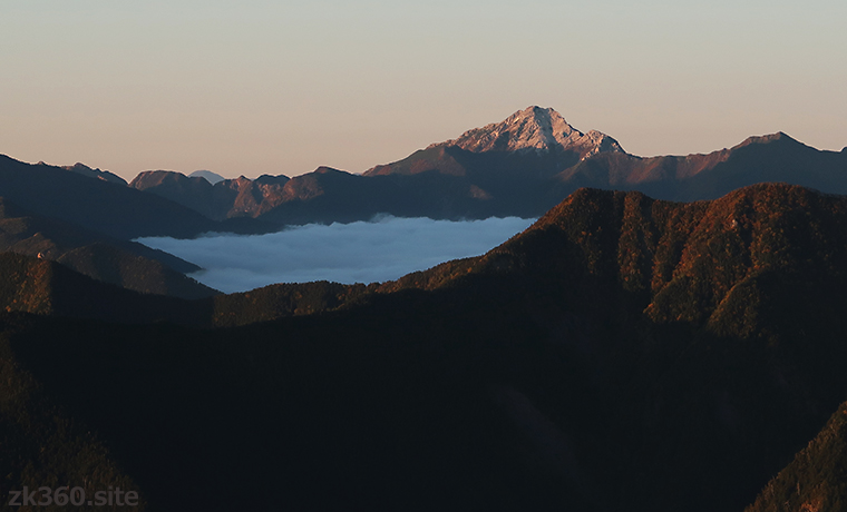
 Photo 6: Mt. Kaikoma dyed in the setting sun as seen from near the Shiomi hut. The mountains look different from the daytime. (Photo: 2019/10/9)
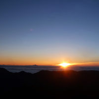
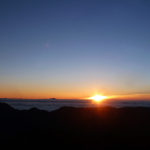
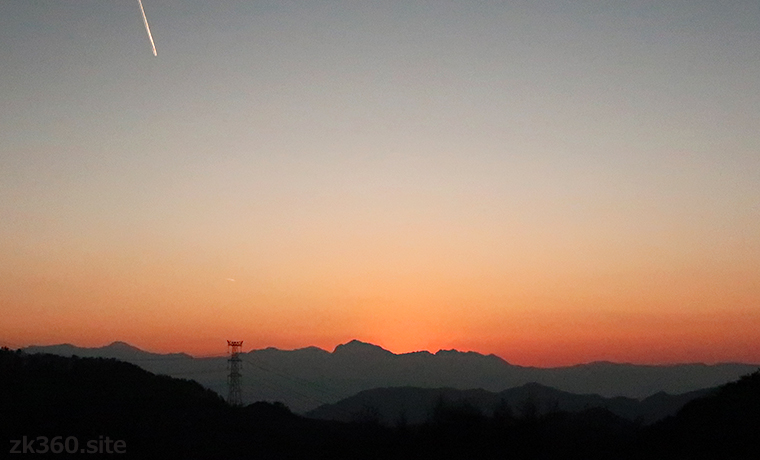
 Photo 7: Silhouette of Mt. Kaikoma in the evening light, seen from Mizugakiyama Natural Park in Yamanashi Prefecture. Its unique shape is impressive. (Photo: 2020/11/17)
The title image changes every 5 seconds.
White sand is dazzling on the summit of Mt. Kaikoma.
The Southern Alps of Japan (Akaishi Mountains) is located on the border of Yamanashi, Nagano, and Shizuoka prefectures, and has a length of about 120 km.
Kyuya Fukada, the author of “One Hundred Mountains of Japan” chose 10 mountains from the Southern Alps. Mt. Kaikoma is the northernmost of them. And it is a popular mountain that is not only stylish but also good for mountaineering.
Drive along the Chuo Expressway from Tokyo toward Matsumoto, and after crossing Kofu, you will see high mountains on your left. Mt. Kaikoma is among them, and the cool mountain scenery and Marishiten’s unique shape are eye-catching.
If you remember the shape, you will be able to distinguish it from a distance. The slopes on the south side look white as if they were covered with snow even in summer. The reason is that it is covered with crushed granite sand.
From the summit, you can see not only the main mountains of the Southern Alps, but also the Northern Alps, the Central Alps, Yatsu-ga-take, and Mt. Fuji. Mt. Kaikoma itself is a nice mountain, and the view from the top is also the best.
Also, I think the good point of this mountain is that it is easily accessible from both Tokyo and Nagoya. From these areas, it may be easier to reach than the Northern Alps.
Please enjoy the 360-degree spherical panoramic photo taken at the summit of Mt. Kaikoma.
* Click the word THETA at the bottom left of the screen to see a wider screen.
この写真は、Webサイト『絶景360』の一部です。『絶景360』は、こちら(https://zk360.site)からご覧いただけます。 – Spherical Image – RICOH THETA
Spherical panoramic photo 1 at the summit of Mt. Kaikoma (2016/8/4)
Although it was still 8:10 am, summer clouds broke out in the southeast, and unfortunately some mountains were hidden. However, on a clear day, you can see the Northern Alps.
この写真は、Webサイト『絶景360』の一部です。日本語版は、こちら(https://zk360.site)からご覧いただけます。 This photo is part of the website “zk360.site”. English version URL is https://e.zk360.site/ – Spherical Image – RICOH THETA
Spherical panoramic photo 1 at the summit of Mt. Kaikoma (with mountain names)
Even for the mountains that cannot be seen in the clouds, the mountain names are put in parentheses so that you can see the rough direction.
この写真は、Webサイト『絶景360』の一部です。『絶景360』は、こちら(https://zk360.site)からご覧いただけます。 – Spherical Image – RICOH THETA
Spherical panoramic photo 2 at the summit of Mt. Kaikoma (2016/8/4)
Another shot on the northeast side of the mountaintop. The front of the stone shrine is on this side, and straw sandals are dedicated. The triangulation point is behind the shrine.
“Kaikoma” means “horse mountain” in Japanese.
In this article, the name of the mountain is written as Mt. Kaikoma. However, it is called “Kai-koma-ga-take” in Japan.
The first “Kai” is the place name. The Yamanashi prefecture was formerly called “Kai”. The next “koma” is an old word meaning horse. “ga” means “of” and “take” means “steep mountain”.
In other words, “Kai-koma-ga-take” means “horse mountain in the Kai region”. However, we Japanese also abbreviate the name of this mountain and call it “Kai-koma”.
By the way, there are many mountains called “Koma-ga-take” in Japan. Kai-koma-ga-take, Kiso-koma-ga-take, Aizu-koma-ga-take, and Echigo-koma-ga-take have been selected for “One Hundred Mountains of Japan”. Minami-koma-ga-take, Akita-koma-ga-take, Koma-ga-take in Hakone, and Koma-ga-take in Hokkaido are also popular.
Kiso, Aizu, Echigo, and Akita are all Japanese place names. Or an old place name. Each mountain is in the area. In addition to these, there are about 20 mountains called “Koma-ga-take” in Japan.
The reason why we call it “Koma-ga-take” or “horse mountain” is generally said as follows. In spring, horse-shaped snow (or rock) appears on the slopes of the mountain. And it’s time to start farming.
There are other theories such as horse-shaped rocks and legends about horses. I did some research, but I couldn’t identify the origin of the name of Mt. Kaikoma.
Among the Koma-ga-take in Japan, Mt. Kaikoma has the highest altitude of 2967m. Next is Kiso-koma at 2956m, then Minami-koma at 2841m, Aizu-koma at 2133m, Echigo-koma at 2003m and Akita-koma at 1637m.
However, there is also a Koma-ga-take at the top of Mt. Fuji. If you climb from the Fujinomiya route to the edge of the crater, you will find a large stone shrine. There is a small peak beside it, which is also called Koma-ga-take. And the altitude is 3710m.
“Then, is Mt. Kaikoma second?”, But among the independent Koma-ga-takes, Mt. Kaikoma is the highest. And Mt. Kaikoma is a mountain worth climbing.
Mountain area
Northern part of Japan’s Southern Alps.
How to access to Mt. Kaikoma
(1) Take a bus from both the Yamanashi side and the Nagano side to the Kitazawa Pass. Private cars are closed all year round. It takes about four and a half hours from Kitazawa Pass to the summit.
(2) The Kuroto ridge on the northeast side is known as a historical route, but the altitude difference is about 2200m and it is for advanced climbers.
(3) There is a route leading to Mt. Nokogiri in the northwest, but it is more difficult to reach Mt. Nokogiri than climbing Mt. Kaikoma, and it is a tough course for experts.
To A-Z index
To area index