 In Japan, Yari-ga-take or Mt. Yari is more popular than Mt. Fuji for mountain lovers. Many climbers are climbing Mt. Yari aiming for the sharp peak.
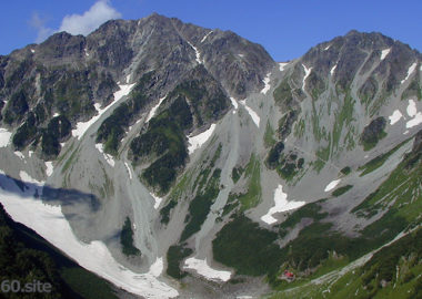
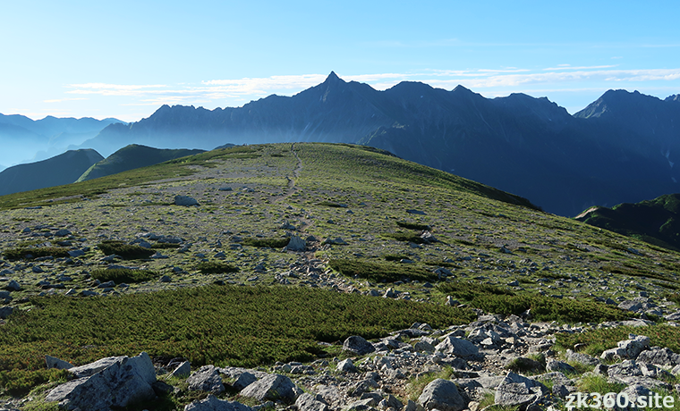
 Photo 1: Mt. Yari seen from the summit plateau of Mt. Sugoroku. One of the famous places in the Northern Alps, where the mountain trail extends toward Mt. Yari. (2019/8/6)
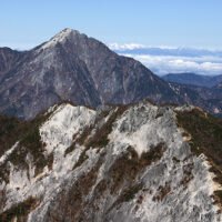
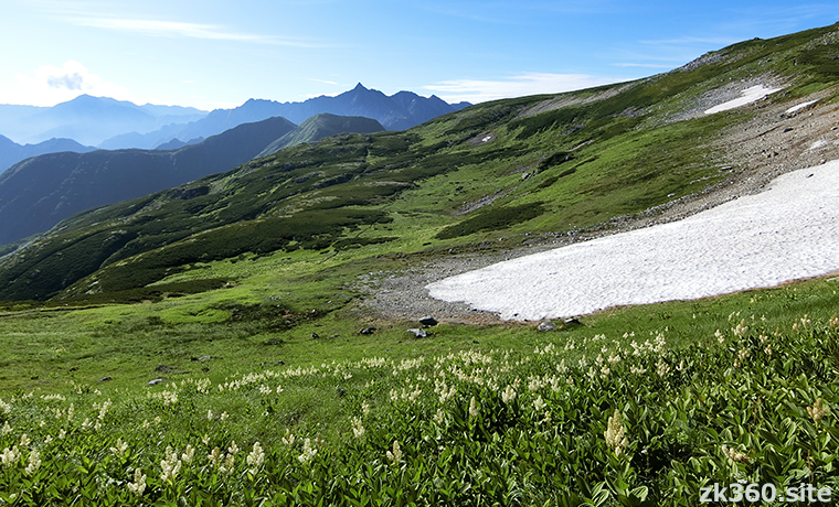
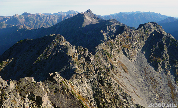
 Photo 2: Mt. Yari seen from the ridge leading from Mt. Sugoroku to Mt. Mitamata- Renge. Mt. Yari can be recognized as ” It’s Yari ” at a glance even from a distance. (2019/8/6)
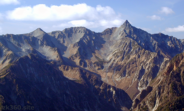
 Photo 3: Mt. Yari seen across Yarisawa from the Jonen Mountains. From this position, the spear-like peak of Mt. Yari looks the sharpest and most beautiful. (2001/10/27)
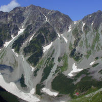
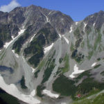
 Photo 4: Mt. Yari seen from Mt. Oku-hotaka. From Mt. Oku-hotaka, you can reach Mt. Yari via Mt. Karasawa, Mt. Kita-hotaka, and a large col called Dai-kiretto. (2016/9/30)
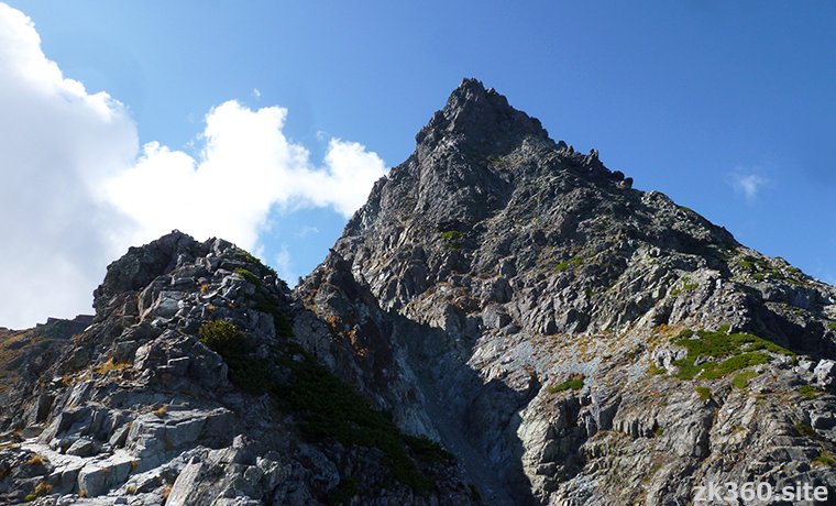
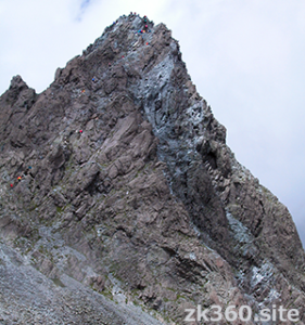
 Photo 5: Looking up at the top of Mt. Yari from Higashi-Kamaone. At the end, climb the steep slope on the left side, relying on chains and ladders. (2017/9/26)
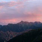
 Photo 6: Mt. Yari seen from the summit of Mt. Kita-hotaka over Dai-kiretto. The big slopes shine in the setting sun, and a mountain day ends. (2002/10/3)
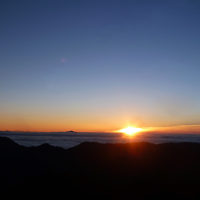
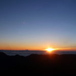
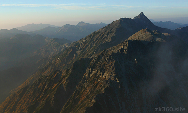
 Photo 7: Mt. Yari before dawn as seen from the summit of Mt. Kita-hotaka. A sharp mountaintop emerges in the dim light. (2017/9/29)
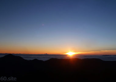
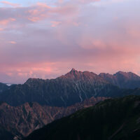
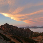
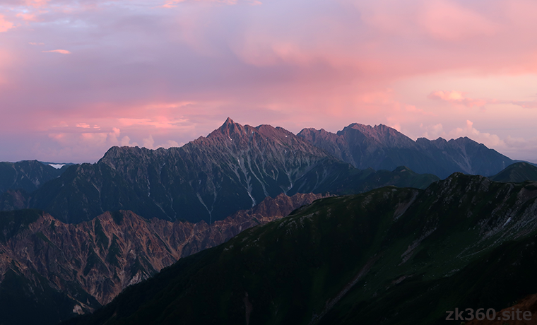
 Photo 8: Mt. Yari and Hotaka mountain range dyed in the sunrise seen near the Suisyo hut. There are few chances to encounter such a superb view. (2019/8/7)
The title image changes every 5 seconds.
The summit is a great observatory overlooking the Northern Alps
The name of this mountain is Yari-ga-take, but we often just call it “Yari”. In this article, this mountain is referred to as Mt. Yari.
“Yari” means “spear” in Japanese, and “Yari-ga-take” means “mountain of spear”. It is so called because of the shape of the sharply pointed mountain peak.
Mt. Yari is very popular among Japanese climbers. There are few climbers who like mountains but don’t know Mt. Yari. Its altitude is 3180m, which is the fifth highest in Japan. However, it may be more famous than the second highest Mt. Kita-dake.
Anyway, its appearance is cool. The unique sharp and pointed top of the mountain can be identified as “It’s Yari” at a glance even when viewed from a distance. First of all, please enjoy the beautiful appearance of Mt. Yari with title photos of this article.
Mt. Yari is often said to be “a mountain of longing” or “someday to the peak of Yari”. However, I think most climbers with some mountain experience have climbed Mt. Yari.
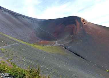
In fact, the top of the mountain is extremely steep. However, it is a general mountain trail with chains and ladders. It may be difficult for beginners, but if you have experienced the Northern Alps of Japan or Mt. Yatsu-ga-take several times, it is probably okay.
The top of Mt. Yari seen from the front of the Yari-ga-take mountain lodge. Climbers aiming for the summit look small.
The view from the summit of Mt. Yari is outstanding. You can see the almost mountains of the Northern Alps.
To the south are the Hotaka mountain range, Mt. Yake-dake, and Mt. Norikura. To the west are Mt. Kasa, Mt. Sugoroku, Mt. Kurobe-goro, and Mt. Yakushi. To the east, Mt. Jonen to Mt. Otensho. You can see Mt. Tateyama in the north and the Ushiro-tateyama mountain range such as Mt. Shirouma beyond that.
Then, please enjoy the daytime scenery seen from the summit of Mt. Yari with a panoramic photograph of the whole sky. One unfortunate thing is that Mt. Kasa is hidden in the clouds. I could see it just before I climbed the mountaintop …
*The following 3 spherical panoramic photos can be viewed on a wider screen by clicking the letters THETA at the bottom left of the screen.
この写真は、Webサイト『絶景360』の一部です。日本語版は、こちら(https://zk360.site)からご覧いただけます。 This photo is a part of the website "zk360.site". The URL of English version is https://e.zk360.site/ – Spherical Image – RICOH THETA
Spherical panoramic photo at the summit of Mt. Yari (2017/9/26)
この写真は、Webサイト『絶景360』の一部です。日本語版は、こちら(https://zk360.site)からご覧いただけます。 This photo is a part of the website "zk360.site". The URL of English version is https://e.zk360.site/ – Spherical Image – RICOH THETA
Spherical panoramic photo at the summit of Mt. Yari (with mountain name)
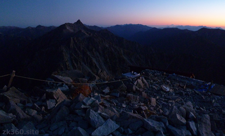
The next morning, I went to the summit again at sunrise time. However, I couldn’t see the rising sun because thin clouds were spreading.
After waiting for a while, the clouds were getting smaller, and the mountains of the Northern Alps were exposed to the rising sun, creating a moving view that was different from the daytime. This time we can see Mt. Kasa well.
この写真は、Webサイト『絶景360』の一部です。日本語版は、こちら(https://zk360.site)からご覧いただけます。 This photo is a part of the website "zk360.site". The URL of English version is https://e.zk360.site/ – Spherical Image – RICOH THETA
Mountains in the Northern Alps shining in the morning sun (2017/9/27)
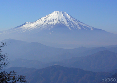
How to find Mt. Yari from afar
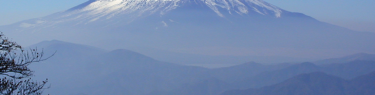
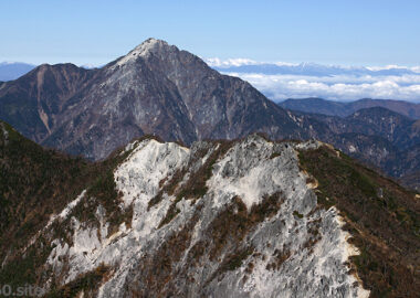
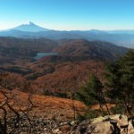
In the southern part of the Northern Alps, Mt. Yari is easily recognizable. However, when you are far from Utsukushi-ga-hara, Mt. Tateshina, and Mt. Yatsu-ga-take, the mountains of the Northern Alps and Central Alps look like jagged folding screens, making it difficult to identify the mountains.
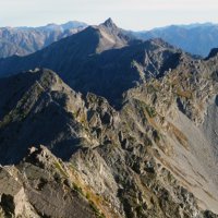
Therefore, it is good to remember the ridgeline in the photo below. If you look at the Northern Alps from the east side, you can see this shape toward the south (left). When viewed from the west, the left and right sides are reversed.
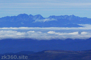
The highest point on the left side of this photo is Mt. Oku-Hotaka. The small triangle on the right of it is Mt. Karasawa, and the one that seems to be tilted to the right next to it is Mt. Kita-hotaka. And the lower part in the center is a big col called Dai-kiretto.
From Dai-kiretto to the right, Mt. Minami-dake, Mt. Naka-dake, and Mt. Obami-dake continue, but it is difficult to distinguish at this distance. And Mt. Yari stands on the right end.
The top of Mt. Yari is often hazy and difficult to see from a distance. However, if you remember this silhouette from the Hotaka mountain range to Mt. Yari, you can find it even from a distance. I took this picture at Mt. Yatsu-ga-take.
Visit a spectacular spot where you can see “upside-down Yari”
There are many places where Mt. Yari looks beautiful. And there are two spectacular spots where you can enjoy the “upside-down Yari” reflected on the surface of the water.
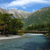
If you start from Kami-kouchi and walk along Yarisawa, you will find the Tengu-hara branch. Go to the right when heading straight for Mt. Yari. If you go to the left, you will reach Tengu-hara in about 40 minutes.
Tengu-hara branch. If you want to see “upside-down Yari”, go to the left.
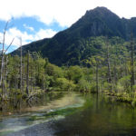
There is a Tengu pond in Tengu-hara, where you can see the top of Mt. Yari and “upside-down Yari” at the same time. This is one of the famous places to see Mt. Yari.
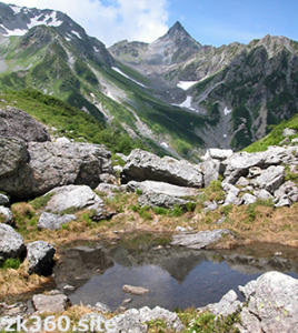
The top of Mt. Yari and the “upside-down Yari” reflected in the Tengu pond.
Another “upside-down Yari” scenic spot is Kagami Pond. “Kagami” means mirror in Japanese.
From Shin-hotaka Onsen, head toward Mt. Sugoroku and climb the mountain trail called Koike Shindo. Then, before you reach the ridge, there is a place called Kagami-daira. And the Mt. Yari and Hotaka mountain range seen from there, and the upside-down Yari reflected in the pond are superb views.
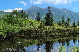
Mt. Yari seen in Kagami-daira and the tip of Yari reflected in Kagami pond.
However, the position where you can see the tip of Yari reflected in the pond is limited. Change your standing position and eye height to find a place where you can see it.
By the way, to get to Mt. Yari from Kagami-daira, you need to go up to Sugoroku Hut and walk Nishi-Kamaone from there. Alternatively, go down to the entrance of Koike Shindo and climb back over Mt. Okumaru. Both routes are long distances. Therefore, I think Kagami-daira should stop by when going to the headwaters of the Kurobe River or Mt. Kasa.
Mountain area
Southern part of the Northern Alps
Access to Mt. Yari
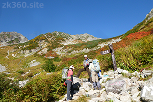
The area around Mt. Yari is a very popular mountain area. Therefore, there are many mountain trails. Which course you choose, aim for Yari-ga-take Sanso hut on the shoulder of Mt. Yari. There is only one route from Yari-ga-take Sanso to the summit of Mt. Yari.
(1) The most common course is to enter the mountain from Kami-kouchi and stay overnight at Yarisawa Lodge or Baba-daira Campground. The next day, go up to Yari-ga-take Sanso hut. And finally, climb the top of Mt. Yari.
(2) I also recommend a route to change the course from Kami-kouchi on the way and see “upside-down Yari” at Tengu Pond. After that, go up to the ridgeline extending south from Mt. Yari and aim for Mt. Yari via Mt. Naka-dake and Mt. Obami-dake. Alternatively, you can use this route for the descent.
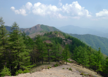
(3) There is also a route to climb from Yarisawa to Higashi-Kamaone. From Omagari, go up to Minamata Nokkoshi and walk along the Higashi-Kamaone while looking at Mt. Yari in front of you. However, Higashi-Kamaone is not for beginners because it has steep rocky roads.
(4) It is also a standard course to start from Shin-hotaka Onsen and aim for Mt. Yari along the Migi-mata valley. It is common to stay overnight at Yari-daira Hut on the way. Beyond that, there are two routes, one that goes up the slope from the Senjo branch to Hida Nokkoshi and the other that goes up to the ridgeline toward Senjo Nokkoshi.
(5) There is also a route that starts from Shin-hotaka Onsen and goes up to Mt. Minami-dake from Yari-daira Hut. From Minami-dake, it is a pleasant course to walk along the 3000m-class ridgeline toward Mt. Yari.
(6) The mountain trail from Mt. Tsubakuro to Mt. Otensho in the northeast of Mt. Yari is a popular route called the Omote-ginza course. Then, you can reach Mt. Yari by following the ridge road called Kisaku Shindo from Mt. Otensho. However, this ridge is a difficult trail that is also called the Higashi-Kamaone.
(7) There is also a route from Nishi-Kamaone to Mt. Yari. Start from Shin-hotaka Onsen and go to Sugoroku Hut via Kagami-daira. Then climb Mt. Momisawa and walk along the Nishi-Kamaone towards Mt. Yari.
To A-Z Index
To Area Index